ASPEN-MARSHALL GULCH LOOP
Pusch Ridge
Wilderness
 |
| Marshall Gulch trail |
Half blaze-ravaged moonscape, half
creek side woodland, this famously crowded loop hike makes for an
interesting first-hand look at the cycle of wildfire forest
destruction and subsequent regeneration.
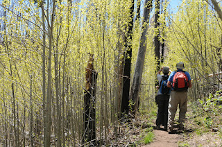
Willowy, white-barked aspens--the
quintessential trees of mountain climes--depend on fire for their
survival. This species needs lots of sunlight to grow and reproduce,
and their natural lifecycle includes succumbing to the shade and
crowding brought on by encroaching conifers. When wildfires clear
the trees and open the forest floor to sunlight, aspens shoot up
rapidly, and right now, they’re having a heyday on the slopes of
Mt. Lemmon.
 |
| Aspen Trail |
A hike on the Aspen-Marshall Gulch loop
showcases this miracle of nature in progress. The tour begins on
Aspen Trail #93, progressing uphill through a patchwork of burned
areas, fir woodlands and clusters of aspens. Soon, the path enters a
dell of slender white-trunk sprouts with vivid green leaves that
rustle and sway in a graveyard of charred pine stumps. Beyond this
point the route ducks in and out of scorched tracts and intact
woodlands before emerging on a sooty, snag-cluttered saddle. Here,
the dramatic effects of recent blazes draw visceral reactions. It’s
a charred and barren scab of a place. The trail gets a bit sketchy
in this area, so watch for cairns leading up to the junction with
Marshall Gulch Trail #3. Here, the route leaves the ashen badlands
passing through a labyrinth of stone before heading downhill and into
another world replete with creek side maples, ferns and alders
rounding out the dichotomous flavor of this hike.
 |
| View from Aspen Trail |
LENGTH: 5.1-mile loop
ELEVATION: 7,410 – 8,400 feet
RATING: difficult
DISTANCE FROM PHOENIX: 158 miles
one-way
GETTING THERE:
 |
| Aspen sapplings |
From I10 in Tucson, take the Grant Road
exit 256 and go 8.7 miles east to Tanque Verde Road. Turn left and
continue 3.4 miles to Catalina Highway go left and drive uphill 27
miles through Summerhaven to the end of the road at the Marshall
Gulch picnic area. Roads are 100% paved.
FEE: $5 Catalina Highway daily fee per
vehicle
FACILITIES: restrooms, picnic area,
INFO: Santa Catalina Ranger District,
Coronado National Forest, (520) 749-8700
0 comments:
Post a Comment