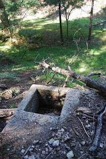


WILDCAT SPRING Coconino National Forest Lavishly overgrown with greenery, the Wildcat Spring trail explores an idyllic high-country ravine. The route is made up of sections of old dirt roads and footpaths that trace the flow of a trickling creek. Attractions along the way include fossil-encrusted limestone rock formations—remnants of the area’s underwater past--and a vibrant gallery of wildflowers including red cinquefoil, New Mexico Checker mallow and yellow columbine living among huge clumps of emerald ferns. Near the end of the trail, the source of the creek reveals itself at a dilapidated concrete box built into the hillside to collect the sporadic waters of Wildcat Spring. HIGHLIGHTS: fragrant pine forest, trickling creek, abundant wildflowers, old spring LENGTH: 3 miles roundtrip RATING: easy ELEVATION RANGE: 7,100 – 6,900 feet DRIVING DISTANCE FROM PHOENIX: 135 miles one-way GETTING THERE: From Payson, go north on Highway 87 for 32 miles to Forest Road 616, which is located past milepost 284 on the left. Follow FR 616 for 3.3 miles to an unsigned campground downhill on the right. INFORMATION: 928-477-2172 or www.fs.fed.us/r3/coconino
FIRE UPDATE, AUGUST 24, 2011: Sand Rock Fire Moisture received over the last week resulted in minimal fire activity. If a drying trend occurs, fire managers will re-access and may continue management ignitions. Several Forest Roads within the fire perimeter remain closed for public access, as well as closed to camping. Smoke is noticeable along Highways 260 and 87, especially at night and early morning. Roads Closed: Camping is discouraged and forest roads are closed in the immediate fire area, including 604, 609, 616 from FR 149 out of Pivot Rock Canyon, 9387G, 9384A, 9386F, 9381, 6304 and FR149 from Hwy 87 to FR144. Behavior: Low intensity in ponderosa pine, oak, juniper and some fir understory. Start Date: July 21 and 28 Resources: 1 Engine, plus additional firefighters; about 10 total. Managed by Mogollon Rim Ranger District. Location: Near junction of Highways 260 and 87. Size: 3600 acres. Possible growth up to 14,000 acres. FOR MORE INFO, CHECK www.fs.fed.us/r3/coconino
0 comments:
Post a Comment