Thursday, April 4, 2013

A storm of seeds


RIO SALADO HABITAT RESTORATION AREA


Downtown Phoenix


Cottonwood seeds in irrigation channel


Like ephemeral misty extras in a fantasy film, a matinee of
billowy white cottonwood seeds are now playing in downtown Phoenix.  If you've ever watched movies that
feature elves, forest faeries or warring factions of sword-wielding gladiators,
then you may have noticed how Hollywood likes to use  mood-enhancing showers of airborne white stuff (seeds, snow,
ash) to build drama while tickling trees and mythical characters alike.  That's what it looks like right now
along desert waterways where the seeds of female cottonwood trees are   The easy trails
of Rio Salado Habitat Restoration Project offer quick, barrier-free access to
this annual natural event which runs through mid-April.


Seed drifts beneath mesquite trees

bursting
free and hitching rides on air currents before settling into lofty drifts among
blooming shrubs.


LENGTH:


To 19th Ave: 
2.0 miles one way


To 7th Ave 0.8 miles


To 12th Ave scenic overlook: 1.2 miles one way


Basic stroll on paved surfaces: 0.5 mile one way


ELEVATION: 
1050' - 1070'


RATING: easy, paved, partially barrier-free


DOGS: allowed but leash & waste pick-up laws are
strictly enforced to protect the habitat


HOURS:  sunrise
to sunset (or 7 pm, whichever comes first)


GETTING THERE:


There are several access points.  The cottonswoods are best at the Central Ave location at
2439 S. Central Ave. Phoenix.


INFO: City of Phoenix, 602-262-6863


MORE PHOTOS:


Sunday, March 31, 2013

Marvelous places with lots of trees


MOUNT ELDEN ENVIRONMENTAL STUDY AREA


Flagstaff


I grew up in the projects outside of Hartford CT.  As kids, the nearest semblance of the
great outdoors for my friends and I was “Clay Mountain”, a vacant lot across
the street, which the town folks used as an impromptu dump and summer car
burning venue.  Next to chasing tar
trucks through our asphalt jungle, escaping to Clay Mountain, with its
scraggly, over-climbed trees, anemic scrub and festering pools of
tetanus-infused toxic waste, was our go-to destination for recreation.  We thought we were the luckiest kids in the universe.    Of course, we really weren’t allowed to go there, but, well, what can I say?  Summer camp and trips
to fishing lakes had exposed us to the bigger wonders of Nature, but our worlds
were still too cloistered to grasp the concept that some kids actually lived
within walking distance of marvelous places with lots of trees.
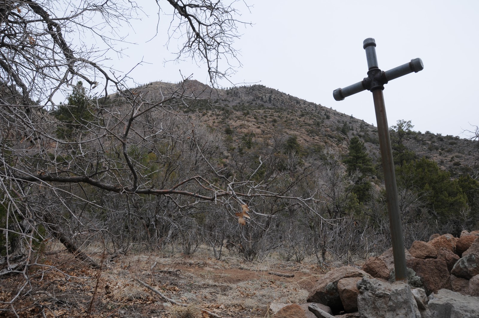


Grave of John Elden


Since then, my hiking habit has lead me to many easy-access,
kid-friendly and educational outdoor classrooms.  One of my favorites is a familiar haunt to the lucky kids at
Flagstaff’s Christensen School. 
Mount Elden Environmental Study Area is a maze of short exploratory
trails with intriguing names like “Forces of Nature” and “Walk Through
Time”.  Located a stone’s throw
from busy Flagstaff Mall and just a short walk from the school, the easy trails
are intended to educate young and old alike about the natural and human history
unfolding at the base of Elden Mountain. 
The trails are a wiggle through a concoction of volcanic boulders,
spring water, Ponderosa pines and blooming shrubs backed by a muffled
soundtrack of trains and traffic along Route 66.  This forest-urban interface at the edge of a trailer park
where everybody has chickens, kind of reminds me of my childhood stopping
grounds---except without the biohazards---unless you count the underground gas
lines.  Lucky kids.  Yet, in the middle of all this
wonderful, walk-able wilds lies one not so lucky kid. Six-year-old John Elden,
(the youngest son of the family for whom the mountain is named) who in 1887 was
tragically killed by a renegade muleskinner’s errant bullet is buried beneath a
sprawling Alligator juniper tree along the main trail just beyond the spring at
the base of what was undoubtedly his own version of Clay Mountain.


Elden Spring


LENGTH:  2.5
miles (I actually hiked on Pipeline up to Oldham trail and back to add a few
more miles, but, that’s not this story)


RATING:  easy


ELEVATION: 
6800’ – 7200’


FACILITIES: none, but there are restrooms and ice cream
(lucky kids) at the Mall.


GETTING THERE:


From Phoenix, travel north on I17 to Flagstaff.  Drive into town and head east on
Route66/US 89 to the traffic signal at Flagstaff Mall.  Turn left on Cummings and drive 0.2
mile to the Christensen School, veer left onto El Paso and go 0.3 mile to a
parking lot on the right across from Hamblin Road. The trailhead is the
unsigned, white gate. 


HIKE DIRECTIONS:


From the trailhead, hike 0.25 mile uphill on the pipeline
road to a large wooden Elden Environmental Study Area sign.  Turn right and follow the main path
that will lead to the spring, Elden homestead site and John Elden’s grave.  A few yards beyond the gravesite turn
left and follow Pipeline Trail back to the trailhead.  NOTE:  explore
the many side trails at will.  Just
return to the main path to complete the loop.


INFO: Flagstaff Ranger District, Coconino National Forest


MORE PHOTOS:


Wednesday, March 27, 2013

Springtime water play


BELL TRAIL


Wet Beaver Creek Wilderness


Wet Beaver Creek


The weather is heating up and soon we'll be heading to higher elevations in search of cool summer trekking. But right now, with temperatures hovering between warm and torrid, a visit to the high desert, swimming holes of Wet Beaver Creek is just the ticket for a refreshing day trip.   Few things are more invigorating on a
sweltering day than a dip in a canyon stream. The Bell
Trail #13 leads to one of the most beloved of all Arizona swimming
holes—“the crack”. Tucked into a slender slot canyon where the
chilly, spring-fed waters of Wet Beaver Creek flow year-round, this
natural water park attracts droves of visitors.


The hike in is completely exposed to
the sun, but never strays far from the creek with its lush riparian
vegetation, numerous shallow pools and slick-rock water chutes. At
the 3.25-mile point, the trail comes to a junction near Bell
Crossing. Although the official route veers right, crosses the creek
and climbs 1,200 feet to the top of the Mogollon Rim, those in search
of plunge must hang a left instead and head for the red cliffs that
form “the 


Rapids at Bell Crossing


crack”.


LENGTH: 6.5 miles roundtrip


RATING: moderate


ELEVATION: 3,880 – 3,980 feet


FACILITIES: restroom, nearby camping


DRIVING DISTANCE FROM PHOENIX: 115
miles


GETTING THERE:


From Phoenix, travel north on I-17 to
exit 298. Go left (east) onto Beaver Creek Road (Forest Road 618)
and continue 2.1 miles to the trailhead on


The Crack

the left.


INFORMATION: Red Rock Ranger District, Coconino National Forest, 928-203-7500, 


Monday, March 25, 2013

Volunteer to replant Schultz Fire burn area


From: "Magee, Brienne U -FS" <bmagee@FS.FED.US>
Date: March 25, 2013 2:18:43 PM PDT
To: <USDA-FS-NEWS@NEWSBOX.USDA.GOV>
Subject: SOUTHWESTERN-NEWS-RELEASE: Coconino National Forest Information


Forest Service hosting public volunteer events to help replant Schultz burn area


Flagstaff, AZ
The
Flagstaff Ranger District is inviting volunteers to help replant
approximately 2,500 ponderosa pine trees in the Schultz Fire burn area.
Public volunteer events will
be held on three Saturdays in April. Each event is limited to 50
volunteers; those interested should sign-up in advance by contacting
Justin Loxley, Flagstaff District Volunteer Coordinator, at
jdloxley@fs.fed.us or 928-527-8213.


When:


Saturday, April 6


Saturday, April 13


Saturday, April 20 (Earth Day Weekend!)


Events
begin at 8:30 a.m. and will last until approximately 1:00 p.m. 
Volunteers should arrive by 8:30 to attend the safety briefing and
planting demonstration.


Where:
The planting areas are located off of Schultz Pass
Road (Forest Road 420), approximately 12 miles north of Flagstaff on
Highway 89 and approximately 5 miles on forest roads.  The road should
be suitable for most cars; however persons with low clearance vehicles
are advised to drive carefully. Specific directions
and details will be given at registration.


What to Bring:
Sturdy
shoes, long pants, gloves, hard hats or bike helmets if you have them,
sunscreen, appropriate dress for the weather, snacks or lunch, and
plenty of water. Planting
tools will be provided by the Forest Service.


Who:
Anyone
eager to help with the Schultz Fire recovery efforts. Participants of
all ages are welcome; minors must be accompanied by a parent/guardian.


For
other general information on the Schultz burn recovery and restoration
efforts, contact the Flagstaff Ranger District at 928-526-0866 or visit
our website at
www.fs.usda.gov/Coconino


###


Sunday, March 24, 2013

A pilgrimage to Mount Francis


MOUNT FRANCIS


Prescott


Near the summit of Mount Francis


Aspen Creek Trail


For me, planning this hike was torture.  Each time I put it on my calendar, my
efforts were thwarted by rain, snow, hail or schedule conflicts.  I was beginning to feel as if the
powers that be didn’t want me to bag this peak.  Then, out of the blue, just as the newly elected pontiff
emerged as pope Francis, the weather cleared.  Was it a happy coincidence---or, a miracle?  Certainly, His Holiness has bigger
concerns than my hiking itinerary, but I had to wonder (even though I’m not
Catholic) if the break in the weather, a hike up Mt. Francis and a new pope
named Francis aren’t--ya know-- connected.  Still, whatever your religious affiliations, it’s hard to
deny that trekking in the "cathedral of the great outdoors" is a great way to
renew the spirit.  Counts for
church! Now, on to the hike details.


East Copper Spring


There's no shortage of hike-able peaks in the Prescott area
and this sweet little find on the fringes of log-cabin-vacation-home-land holds
its own among its loftier, more remote commrades.  Remarkably easy to access for a mountain trek, the route is
a web of forest roads, ATV tracks and hiking trails.  To seasoned hikers, the tiny 800 feet of elevation change
from the trailhead to the peak may seem like an outing for amateurs, however,
once on the trail, unrelenting dips and climbs easily add up to three times the
advertised ascent.  There are many
ways to hitch together a loop hike using the labyrinth of dirt roads and
footpaths circling the antenna-cluttered peak which resembles a lumpy
knoll.  Therefore, a good map and a
compass will be your best tools to avoid frustration and aimless wandering in
this scrubby terrain of juniper and yucca. And so, in yet another weary homage to
the slogan of this blog, we set off to conquer the mountain and record our
journey for your hiking sanity. 
Here's a description of our route: 
from the trailhead, cross Copper Basin Road and pick up Aspen
Creek Trail #48, follow the “48” signs 2.9 miles to the junction with East Copper
Trail #260.  Turn right (north) and
hike 0.5 mile to a 3-way junction with a gate. Head up the road with the gate
to the summit of Mt Francis.  Once
done exploring the peak, head back down to the first shed with antennas and
turn right onto the road below the power lines.  Soon, you’ll pass thru another gate.  At this point, you’re on FR9402D.  Follow this aspen-fringed track to
Copper Basin Road, turn right and hike roughly a mile back to the
trailhead.  NOTE:  Along FR9402D, you will notice several
side roads on the right blockaded with boulders.  According to my research, these theoretically head northeast
to connect with trail #48. 
However, we didn’t verify this.


Aspens along FR9402D


LENGTH: 7.8-mile loop


RATING: moderate


ELEVATION: 6266' - 7110'


FACILITIES: none


DISTANCE FROM PHOENIX: 117 miles one way


GETTING THERE:


From Phoenix, travel north on I17 to Cordes Junction and the
turn off for AZ69.  Head into
Prescott on AZ69 (which will become Gurley St) and turn left (south) on
Montezuma St. Continue 1 mile to Copper Basin Road, turn right and go 4.6 miles
on Copper Basin to the Aspen Creek Trailhead on the right.  Roads are paved up to the last 1.6
miles, which is on sedan-friendly dirt.


INFO:


City of Prescott Mile-High Trail System


Prescott National Forest


MORE PHOTOS:


Wednesday, March 20, 2013

Take a hike with wildflower experts

McDOWELL SONORAN PRESERVE WILDFLOWER WALK


Ever wish you knew a little more about the colorful springtime blooms that pop up all over the Valley? Then, join wildflower experts Marianne Jensen and Steve Jones this Sunday for an educational walkabout in the foothills of Scottsdale's McDowell Mountains.  In addition to learning a thing or two, the weather should be perfect and you'll get in a good hike.

WHEN:  Sunday, March 24, 2013

TIME: 7:45 a.m.

WHERE: Tom's Thumb trailhead--directions below.

LENGTH: 3 miles

RATING: moderate, appropriate for ages 10 and older

ELEVATION: 2800' - 2950'

GETTING THERE:


Tom's Thumb Trailhead:


From the loop 101 in Scottsdale, take the Pima/Princess Road exit 36 and continue 5 miles north on Pima to Happy Valley Road.  Turn right (east) and go 4.1 miles on Happy Valley to Ranch Gate. Turn right on Ranch Gate, follow it 1.2 miles then turn right onto 128th St. and continue 1 mile on 128th to the signed trailhead. Roads are paved all the way.


INFO:

http://mcdowellsonoran.org/event/displayEvent/297#sthash.DJygPv3H.xHnEvfDF.dpbs


Monday, March 18, 2013

Wilderness waterfalls


BARNHARDT FALLS


Tonto National Forest


entrance to the grotto


inside the grotto: March 16, 2013


view of the trail with "chevron folds" on left canyon wall


Late winter snowfall followed by suddenly warm days of
spring combine for  a perfect storm for waterworks in the Mazatzal Wilderness.  Because of this, Barnhardt Trail #43
is a busy place from March through early April--peak season for snowmelt waterfalls. In addition to its spectacular display of cascades, the totally canyon bound route zigzags through a complicated stew of geological delights including some spectacular
"chevron folds"---accordion-style bends in the canyon wall created by
millions of years of tectonic forces. 
Also, look for "fossil" waves in the quartzite.  These stone ripple marks are either
preserved ocean-bottom wave action or fingerprints of currents of shallow rivlets.
Throughout the hike, outcroppings of blush-colored quartzite and dragon-scaly shales
are drenched by trickling springs, puddles of melted ice and roaring cascades
of water plunging 2000 feet over rough cut cliffs.  Several stony ledges along the way offer excellent views of
water flowing at the bottom of the canyon and the contorted rock
formations.  A particularly grand vista
can be seen at a the 2.80-mile point where a natural rock shelter embellished
with clumps of pincushion cactus teeters above a vertical drop with big views of the
Mogollon Rim.  Although trail #43
runs for six miles one-way, we like to hike up to the large slot canyon falls at
the 3.14-mile point, climb to the semi-hidden grotto and then return the way we
came.   Amazingly, some hikers
walk right past the slot without even noticing the 100-foot, three-tiered
cataract visible around a bend in the rock. The entry is marked by a gushing,
double water chute as shown in the photo on the left. It takes a bit of scrambling to
get into the grotto at the base of the falls, but the effort pays off in a
memorable shower of icy spray and crystal clear plunge pools. 


the rock shelter


LENGTH: 6.5 miles roundtrip


RATING: 
moderate


ELEVATION: 
4210' - 5580'


GETTING THERE:


From Shea Blvd and AZ87 (Beeline Hwy) in Fountain Hills,
travel 51 miles north on 87 to FR 419. 
This road is located just beyond the sign for Barnhardt Trailhead and
roughly 0.25 mile south of the town of Gisela.  Turn left and go 4.8 miles on FR 419 to the trailhead.  FR 419 is a rutted one-lane track.  Although sedans are frequently sighted at the trailhead, a high clearance vehicle is recommended.


INFO: Payson Ranger District, Tonto National Forest


MORE PHOTOS:


Saturday, March 16, 2013

Video: Barnhardt Canyon waterfalls

BARNHARDT CANYON

Mazatzal Wilderness

The waterfalls along Barnhardt Trail #43 were running wild today. I'll be posting a trip report and photos from today's hike later, but, here's a video of the waterworks in the big grotto.


Friday, March 15, 2013

New & improved Arizona Trail maps now available.


JOIN THE ARIZONA TRAIL ASSOCIATION to gain access to these high-value trekking tools.


The
Arizona Trail Association has announced a new series of online maps
and elevation charts for each of the 43 passages along the Arizona
Trail. The former maps have been replaced by these custom topographic
Passage Maps with the Arizona Trail clearly defined, nearby
trailheads, access roads, and more. They are available for viewing,
downloading and printing under the Passages
page
.


Additionally,
elevation charts for each passage have been reworked and are
available to members only on the same Passages page. After you login
as a member, just click the “YES” icon under Passage Profile.
They are an excellent resource when planning your next Arizona Trail
adventure.


The
new maps and elevation charts are just a few of the useful tools
available in the new Trail Resources page of the Arizona
Trail website
.
 Water
sources, loop hikes, a contact list of trail stewards, and much more
are available for your use. And if you haven’t used the Interactive
Trail Map
 and explored all its features, that should be at
the top of your list of next (virtual) places to visit.


Arizona
Trail Association:


Thursday, March 14, 2013

Now blooming: Phoenix Sonoran Preserve

UNION PEAK-DESERT TORTOISE LOOP

Phoenix Sonoran Preserve


Summit of Union Peak


Some friends just sent me photos of their hike yesterday in this northwest Valley preserve, , and WOW.  Now is the time to go see the wild poppies covering the slopes around Union Peak and Dixie Mountain!


Mexican Gold Poppy


Blackfoot daisy


chuparosa a.k.a. hummingbird plant


LENGTH: many trails, refer to trailhead sign for options

RATING: easy-moderate

ELEVATION:  1,600' – 2,200'

DOGS: dogs must be on leash and handlers must pack
out poo


KID FRIENDLY: yes


FACILITIES: no restroom or water. plenty of
parking, trail map sign, and there’s a special lot for horse trailers


HOURS: 6 a.m to 7 p.m. 

GETTING THERE: 


Desert Vista Trailhead:


From Phoenix, go north on I-17 to Jomax exit.  Go 0.2 mile on Jomax to Norterra
Parkway, turn left (north) and continue 1.2 miles to North Valley Parkway.  Turn right (south) and go 0.2 miles to
Copperhead Trail.  Turn left and go
just a few yards  to Melvern
Trail.  Turn left on Melvern and go
0.1 mile  to Desert Vista Trail on
the right .  Follow Desert Vista
through a gate that leads to the trailhead..


INFO: City of Phoenix, Phoenix Sonoran Preserve


 http://phoenix.gov/parks/trails/locations/sonoran/index.html


Tuesday, March 12, 2013

Superstition Mountains wildflower hike


CROSSCUT-TREASURE LOOP


Tonto National Forest


Brittlebush: March 9, 2013


Blessed with a beveled topography leaning into sun-drenched
exposure, the open rangeland of the western Superstition Wilderness is choice
property for spring wildflowers. In addition to its fortuitous floral fortitude,
the Crosscut Trail is very easy to get to, making it one of the most popular
hikes for viewing annual blooms. A backdrop of abrupt volcanic escarpments that
have been photographed and filmed to death (think, Jerry Maguire) add to the
allure of this Apache Junction tourist magnet. 


Wild hyacinth & cholla cactus


Crosscut trail, which wanders 4.5 miles from First Water Road to
Broadway in Mesa, also connects with a bevy of routes just outside the boundary
of Lost Dutchman State Park.  The
Treasure Loop is a favorite because it gets nice and high, brushing the base of
geologic landmarks like the "Green Rock" and the "Praying
Hands".  For flower lovers,
the 500 feet of elevation gain and entry into damp drainage gullies, produces a
variety of moisture-loving plants (Dainty Desert Hideseed) as well as those
that thrive in more open and arid micro climates (Mexican Gold Poppies).   March and April are the best
months for to see the blossoms before impending heat takes them out for another year. 


view from the trail


HIKE DIRECTIONS:


Follow Crosscut Trail (aka Jacob's Trail #58 and Jacob's
Crosscut) 1 mile to the junction with Treasure Loop #56 and follow the signs.


LENGTH:  3.5
miles


RATING: moderate


ELEVATION: 2580'- 2060'


FACILITIES: none

GETTING THERE:


From Phoenix, travel east on US60 to exit 196 (Idaho
Rd/AZ88).  Go left at the off ramp
and follow AZ88 7 miles to First Water Road (FR78) near milepost 201 on the
right. Go 1 mile on FR78 to the signed Crosscut trailhead on the right. There
is NO fee to park here.


Alternate access: 
For access with restrooms, maps and picnic tables enter via Lost
Dutchman State Park and use the maps posted at the trailheads. The park charges
a $7 daily fee per vehicle.


INFO: Tonto National Forest, Mesa Ranger District,
480-610-3300


MAPS: Lost Dutchman State Park


MORE PHOTOS:


Friday, March 8, 2013

Barrier-free wildflower trails


JUDITH TUNELL TRAILS


South Mountain Park


Judith Tunell Challenge Trail, March 7, 2013


Recently re-paved and groomed these two trails make getting
out into the desert easy for everyone. 
Two connected loop routes offer choices for those with mobility concerns
or families with little kids.  The
Accessible Loop is 100% paved, flat and outfitted with benches, shade ramadas
and interpretive signage giving insight to the local flora, fauna and human
history.  The Challenge Loop,
although also paved, features a slightly steeper grade leading to a scenic rest
point overlooking downtown Phoenix. 
Both loops are perfect choices for viewing spring wildflowers. Right
now, brilliant Mexican Gold Poppies are spilling over the bajadas while vivid
purple lupine and scorpionweed vie for attention among saguaros and hedgehog
cactuses.  Today’s rain will surely
amplify the colorful show, which usually runs wild through April.


Scorpionweed & Gordon's Bladderpod


LENGTH:  1 mile
(two 0.5-mile loops)


RATING: easy, barrier-free


ELEVATION: 
1370’ - 1440


GETTING THERE:


From Phoenix, travel south on Central Ave., which will dead
end at the park entry gate.  Pass
through the gate, take the first left and continue 0.1 mile to the Environmental
Education Center.  Trail begins
behind the center.


INFO & MAPS:


City of Phoenix, South Mountain Park


MORE PHOTOS:


Thursday, March 7, 2013

Urban wildflower hike


TERRACE TRAIL


Rio Salado Habitat Restoration Area


Globemallow, March 7, 2013


Wolfberry, March 7, 2013


She appeared out of a pile of rubble to check me out as I
photographed wildflowers on the flood plain.  The beautiful white pitbull mix kept both her distance and a
watchful eye on my wanderings, never letting me get more than a few dozen yards of her. I dubbed her “Ghost”. Sadly, feral dogs and cats are common in this
5-mile stretch of the Salt River, which cuts through Phoenix just south of
downtown.  Surrounded by quarries
and construction industries, this 595-acre City of Phoenix multi-purpose
project spanning from 19th Ave to 28th Street was
developed to restore the native riparian life zone, improve flood management
and open new recreational opportunities. 
The formerly blighted river corridor was cleared, water pumped in and
thousands of native plants reintroduced into created wetland marshes, mesquite
bosques and cottonwood-willow habitats. Even with all the improvements, the
sights and sounds of the heavy industry end of town are ever present ---planes
overhead, earth movers groaning in the quarries that flank the river and
unfortunate piles of trash carried in on the wind.  Still, it’s important to keep in mind how extraordinary it
is that this place even exists.  And,
for me that’s the draw.  Although
the Terrace Trail is one of the least attractive of the area’s hiking routes, I
find it fascinating to marvel at the variety of life inhabiting this sliver of
green wedged between freeways and barrios.  Beautiful life such as globemallow, wolfberry and popcorn
flowers mix with water fowl, rabbits, lizards and misplaced beasts like Ghost,
who I last saw loping off toward 19th Avenue.


Terraced waterfall & cottonwood trees


LENGTH: 2 miles roundtrip


RATING: 
easy---rocky, unpaved route


ELEVATION: 
1,100’


DOGS:  leashed
dogs are allowed only on paved trails


HOURS: sunrise to sunset or 7 p.m. whichever comes first


GETTING THERE:


There are many access points.  I used the 7th Ave trailhead just south of US 60. Hike west from &th Ave to 19th Ave. 


"Ghost" the feral dog


INFO & MAP:


City of Phoenix, 602-262-6863


Audubon Visitor Center, 602- 468-6470


MORE PHOTOS:


Sunday, March 3, 2013

"Pop up" rivers of melting snow.


CYPRESS-BOULDERS LOOP


Payson


Water on the Cypress Trail: March 2, 2013


Snow on North Boulders Loop: March 2, 2013


The seasons of spring and fall share a common, landscape
transforming magic.  While autumn
is famous for painting the Arizona high country in warm fiery hues, spring
brings on a rush of “pop up” snow melt rivers to our deserts.  March and April are the best months to
view the transient water works in the Payson area.  There’s still enough snow on the peaks and hiding out in
shady canyons to keep ravines and gullies flowing, but it won’t last long.
Located close to town in a surprisingly untamed terrain of weathered granite
dells and abrupt mini-canyons, the Cypress-Boulders Loop, is an ideal place to
experience snowmelt runoff.  The
trail is shared-use and open to hikers, equestrians, bikes and ATVs, and thus
sees lots of action especially during this prime time.  When we hiked here this week, water was
everywhere and we found ourselves hopping rivulets and ogling at water chutes
cascading over bare rock every few minutes.  Forests of pines, junipers and of course cypress trees mixed
in with open, boulder-studded fields form a patchwork of shade and sun along
the route.  Although this hike
would be pretty anytime of year, cool temperatures and rare water make it
exceptional in spring.


HIKE DIRECTIONS:


From the trailhead, follow Cypress Trail 2.5 miles to the
junction for Boulders Trail.  Take
either the north or south leg and hike the 2.7-mile loop back to this junction,
then retrace your steps back to the trailhead.


LENGTH:  7.3
miles round trip


RATING: 
moderate


ELEVATION: 
4485’- 4932’


GETTING THERE:


From Phoenix, travel north on SR87 (Beeline Hwy) to
Payson.  At the intersection of SR87
and SR260, go right and follow 260 less than a mile to Granite Dells Road on
the right just past the Safeway. 
Go 1.9 miles on Granite Dells to a small easy-to-miss sign for Cypress
Trail.  There’s no official parking
area, just find a spot along the road being mindful of the private driveways in
the area.


ALTERNATE ACCESS TO THE LOOP:


Go 3.3 miles on Granite Dells Road (which will turn into
FR435 after 1.3 miles) and park at the Monument Peak trailhead on the left just
before a roadblock.  From here, hike
down to the roadblock on FR435 and hike 0.5 mile (crossing 3 concrete bridges)
to the Boulder Loop trailhead—look for a sign on the cliff wall on the
left.  The trail begins on the dirt
road heading downhill to the right. NOTE: From the first P.A.T.S. sign above
the gorge, the trail continues directly across the gorge.  You can see the signs high on the
opposite embankment. 


INFO:


Payson Area Trails System (PATS)


MORE PHOTOS:


Wednesday, February 27, 2013

Four Forest Restoration Initiative update

Forest Service Provides Early Opportunity to Preview 4FRI Draft Environmental Impact Statement


Coconino National Forest


As avid hikers, we should all be aware of restoration and woodland health efforts planned for the Coconino and Kaibab National Forests.   Today, the forest service released to the public a draft of the plans and how they may impact the landscape.  Our input is encouraged.  Let's be proactive in assuring forest health is maintained while protecting access to public lands.  Here's the press release and link to the draft statement:


FLAGSTAFF,
Ariz. – The Forest Service is providing the public with an early
opportunity to preview the Draft
Environmental Impact Statement (DEIS) for the Four Forest Restoration
Initiative (4FRI).  The DEIS for the first analysis area on the Coconino
and Kaibab National Forests has been posted to the 4FRI website at
www.fs.usda.gov/main/4fri/planning.


In
response to public input, the Forest Service will offer a 60-day formal
comment period on the DEIS, which
will begin with the publication of the Notice of Availability (NOA) in
the Federal Register.  The NOA is expected to be published in late
March.


In order to allow additional time for public consideration of this extensive document, online access to the
DEIS is being made available by the Forest Service prior to the official start of the formal comment period.


“There
are numerous individuals and groups with an interest in this document,”
said Coconino National Forest
Supervisor Earl Stewart.  “We wanted to provide as much time as
possible for people to digest the information and begin to form comments
and questions.”


When the official NOA is published, the Forest Service will announce dates for public meetings.  The public
meetings will provide interested individuals the opportunity to learn more about the DEIS and comment on its contents.


http://www.fs.usda.gov/main/4fri/planning