HIEROGLYPHIC CANYON
Superstition Wilderness
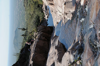
Not too many years ago, getting to Hieroglyphic Canyon in the Superstition Wilderness Area required some effort. A long approach, unclear route and an ever-encroaching quagmire of private property and access restrictions precluded all but the most robust and determined hikers from visiting the canyon and its treasure trove of ancient Hohokam rock art. Recently, the Superstition Area Land Trust (S.A.L.T.) and Pinal County worked together to make Hieroglyhic Canyon more accessible. Through their efforts, a developed trailhead and parking area sprung up where once only limited roadside pullouts served as parking spots. There’s even a porta potty now. At first blush, this was a wonderful accomplishment. These improvements opened up the area to thousands who would otherwise miss the opportunity to learn from and enjoy this national treasure. However, among the trail’s smartly designed informational signage, there’s not a word about the irreplaceable historical significance of the rock art. Archeologists believe the petroglyphs range in age from 2,000 to 200 years old. Images of animals, plants, humans and mysterious geometric designs pecked into the rock veneer give a rare and precious glimpse into the life and culture of Arizona’s native inhabitants. The glyphs are scattered across a segment of the canyon where water runs over stone terraces nearly year-round. It’s a beautiful sight to behold—natural, open and entirely exposed to vandalism and damage from careless visitors. We visited this area early in the morning of February 21, 2009 and arrived at the petroglyph site around 8:30 a.m. By 9:30, the canyon had become overrun with visitors, many of whom proceeded to demonstrate an absolute disregard for historic preservation by climbing on (ON, not around) the artifacts. Young children were allowed to ply the ancient etchings with peanut butter encrusted fingers while cell phone wielding teens teetered atop an elegant set of animal drawings, chattering like baboons as the soles of their shoes chafed the delicate art. Granted, much of this behavior may be happening because people simply do not understand the rock art’s significance and fragility. In fact, while we were there, we conducted an informal query of the perpetrators and found that some of them had no idea the petroglyphs were “real”. Because of all the interspersed modern graffiti, one man assumed that all of the markings were the work of latter-day hoodlums. As the canyon swelled with droves of careless explorers, I struggled with a churning mix of anger, sadness and an urge to scream “get off the friggin petroglyphs!” Instead of making an ass out of myself, I wrote this diatribe—which makes me feel better, but does little to solve problem. You can help by educating your friends, families and co-workers about historical site preservation. Send them the link to this blog posting and the link to the Archeological Site Etiquette Guide shown below. Also, feel free to pester the following agencies at will.
LENGTH: 3 miles round trip
RATING: easy
ELEVATION: 2,050-' 2,620'
GETTING THERE:
From Phoenix, take US 60 east to Apache Junction. Between milesposts 202 and 203, turn left onto Kings Ranch Road and go 2.8 miles to Baseline Road. Turn right and follow Baseline 0.3 mile to Mohican, turn left, go 0.3 miles to Valley View. Turn left and follow Valley View (turns into Whitetail Road) to Cloudview Ave, turn right and continue 0.5 mile to the trailhead.
INFO: Tonto National Forest
http://www.fs.usda.gov/recarea/tonto/recreation/hiking/recarea/?recid=35483&actid=50
Archeological Site Etiquette Guide: http://azstateparks.com/SHPO/etiquette.html Superstition Area Land Trust (S.A.L.T.) http://www.azsalt.org/ Arizona Archeological Society http://www.azarchsoc.org/phoenixchapter.html
We got lost, so you don't have to. 400+ TRAILS. Search for hikes using the TRAIL INDEX on the left side of my blog roll. Happy Trails!
Thursday, February 26, 2009
Friday, February 20, 2009
PICACHO PEAK


HUNTER TRAIL
Picacho Peak State Park
You’ve got to be just a little bit “nuts” to hike to the top of Picacho Peak. Visible for miles along Interstate-10, the imposing heap of lava looks insurmountable. However, the Hunter Trail, with its network of cables bolted into bare rock, guides adventurous hikers to the top. While climbing up along the vertical hardware, you may find yourself questioning your sanity. That’s because most humans have a built-in fear of heights. Squirrels, on the other hand, do not share this trait. The peak’s resident critters seem to enjoy pestering hikers as they toil up the trail. But, don’t be too concerned -- they’re more interested in the snacks in your backpack than testing your mental fortitude. The exhausting climb to the summit rewards with expansive panoramas of the surrounding desert. From the top, Interstate-10 looks like a desolate pale ribbon leading to nowhere. While ogling the views, be sure to keep an eye on your gear or else a nut-loving squirrel might ambush your backpack and run off with your trail mix.
LENGTH: 4 miles round-trip
ELEVATION GAIN: 1,374 feet
RATING: difficult
GETTING THERE:
From Phoenix, drive 75 miles south on I-10 to exit 219, Picacho Road. Once inside the park, follow the main road to the turnoff for Bartlett Loop. The trail starts at the picnic area at the north side of the loop. Wear boots with good traction and bring non-slip gloves to protect your hands on the cables.
Fees: $6 daily fee per vehicle.
Information: pr.state.az.us/Parks/parkhtml/picacho (520) 466-3183
QUARTZ RIDGE
QUARTZ RIDGE TRAIL #8
Phoenix Mountains Preserve
Meandering in the arid foothills and washes beneath Piestewa Peak, the Quartz Ridge trail leads to great views of the Valley--without a lot of uphill climbing. The jewel of this short but interesting trail in the Phoenix Mountains Preserve is a minivan-size chunk of glistening, white quartz nestled in gully full of stony rubble. The crumbling rocks in the area are among the oldest on earth. Some date back billions of years to the era when our planet was transitioning from a mass of molten lava into solidified landmasses that would eventually become the continents. Flecks of mica imbedded in the decomposing stone act like tiny mirrors bouncing sunlight off the spindly palo verde trees, cactuses and creosote bushes that line the path, which tops out at on a sunny, open ridgeline. There, in the shadow of the second highest peak in Phoenix, a breath-taking panorama of a sprawling desert city melts into the horizon.
LENGTH: 5 miles round-trip
ELEVATION GAIN: 220 feet
RATING: easy-moderate
GETTING THERE:
From Shea Boulevard in North Phoenix, turn south on 40th Street and continue to the end of the road and the trailhead parking area. The trailhead is open daily from 5 a.m. to sunset.
Information: Vist, ci.phoenix.az.us/PARKS/hikphgud.html or call (602) 262-7901
BUTCHER JONES TRAIL
BUTCHER JONES TRAIL
Saguaro Lake
Tonto National Forest
Wrapping around the mountains and valleys surrounding one of Arizona’s most popular lakeside recreation areas, Butcher Jones trail offers a surprisingly peaceful hiking experience. However, getting to the “peaceful” part requires some effort. That’s because the first half-mile of the trail is usually congested with anglers, weekend picnic groups, rambunctious kids and manic water dogs. After that, though, the trail emerges from the commotion and climbs exposed desert ridges for spectacular views of the hillsides that form both the harbors and beaches of Saguaro Lake. High points along this gracefully undulating ribbon-like trail hover above cattail-choked coves and pebble strewn beaches with reflections of Four Peaks shimmering in the rich blue waters of the lake. In order to really appreciate the beauty of this trail, be sure to explore the spur paths that plunge to secluded shorelines and shady coves where silken, lazy waves lap at the bases of mesquite bosques and massive forests of saguaro cactuses.
LENGTH: 6.5 miles round-trip
RATING: moderate
ELEVATION GAIN: 400 feet
GETTING THERE:
From Phoenix, go north on Highway 87 (Beeline Highway) to Forest Road 204 (Bush Highway). Continue on the Bush Highway for 3 miles, turn right (east) onto Forest Road 166 and go another 2 miles to the Butcher Jones Recreation Site. The signed trailhead is located at the beach near the dock.
FEE: A Tonto Pass ($6 daily fee per vehicle) is required.
Information: visit fs.fed.us/r3/tonto or call (602) 225-5200
Tuesday, February 10, 2009
LAVA RIVER CAVE


MONTEZUMA WELL
USGS ARTICLE about Montezuma Well: http://pubs.usgs.gov/of/2011/1063/
Saturday, February 7, 2009
FOREST ROAD 48
FOREST ROAD 48
Tonto National Forest
There's really no plan here....just use the road as your arterial route and indulge your inner wild.
LENGTH: 5+ miles roundtrip (optional exploratory)
RATING: moderate (route-finding skills are required)
ELEVATION GAIN: 200 - 800 feet depending on your mood
FEE: There’s a $3 per person entry fee. The self-pay station requires exact change.
GETTING THERE:
To reach the Spur Cross trailhead, From Loop 101, exit at Cave Creek Road and drive north for approximately 15 miles to Spur Cross Ranch Road. Continue north for 4.2 miles to the parking lot on the left. The last mile of the road is good dirt and passable by sedan.
HIKE DIRECTIONS: From the Spur Cross Conservation Area trailhead, follow the Spur Cross Trail north for roughly 2 miles to the Skull Mesa trailhead. From there, continue north on FR 48, tread lightly and explore at will.
INFORMATION: Maricopa.gov/parks/spur_cross or (480) 488-6601
DINOSAUR WASH
DINOSAUR WASH
Wickenburg
Although there are no fossilized bones to be found, many other “dinosaurs” are easy to spot along this exploratory route in the Hassayampa River gorge. The remains of an old manganese mine, a hermit’s roost and a smattering of petroglyphs vie for attention among towering canyon walls, riparian vegetation and sandy, water-filled narrows. Because there’s no formal trail and some boulder scrambling is involved, only experienced hikers should attempt this route, which begins with a steep decent along a Jeep road into the canyon. As the water level in the creek varies from trickling to torrential, it’s smart to avoid the area after heavy rains and come prepared with wading sandals. From the canyon floor, head right and pick your way downstream keeping your eyes open for the many discoveries that lurk in the shadows.
LENGTH: 1-7 miles, exploratory hike
RATING: moderate
ELEVATION: 2,420 – 2,744 feet
GETTING THERE: From Phoenix, take Highway 60 west to Wickenburg. Connect to Highway 89/93 and drive north to milepost 195 and turn right onto Scenic Loop Drive. Set your odometer and continue on the dirt road past two cattle guards and an old mine site at mile 6.9. Stay right at the next junction, and then veer right onto an unmarked road at the 7-mile point. The parking area is a short distance ahead, on the rim of the canyon.
INFORMATION: Bureau of Land Management, Phoenix Field Office, (623) 580-5500
MURRAY BASIN: FLAT TOP HILL
MURRAY BASIN: FLAT TOP MOUNTAIN
Apache-Sitgreaves National Forest
Whether you’re a weekend warrior, seasoned power-hiker, mountain biker or an equestrian, the trail system of Murray Basin has got you covered. More than 18-miles of shared-use trails criss-cross the emerald green pinion-and-juniper-studded grasslands in the foothills of the White Mountains. Each of the 10 well-defined trails in the basin is unique –it would take several days to explore all that this scenic area has to offer. Easy options include trails that lead to an old cemetery, cabin ruins and interpretive signs that describe the history of the basin. A more challenging route climbs to the top of Flat Top Mountain (8,120 feet) for great views of the Springerville volcanic field and Mount Baldy Wilderness. Although the Flat Top Mountain hike is a good introduction to Murray Basin it’s helpful to pick up a detailed map of the area at the Springerville ranger station to learn how to access the entire trail network.
LENGTH: 3 miles round-trip
RATING: moderate
ELEVATION: 7,220 – 8,120 feet
GETTING THERE:
From downtown Eagar, go left (east) on Highway 260/180 and continue 3.4 miles to the turnoff for the trailhead on the right between mileposts 403 and 404.
The Flat Top Mountain route: start hiking on the obvious main trail -- keeping left at the unsigned junctions and follow the signs to the top of the ridge.
INFORMATION: Springerville ranger station: www.fs.fed.us/r3/asnf (928) 333-4372
FORD CANYON


FORD CANYON
White Tanks Regional Park
Pick a day with blue skies after a healthy rain to hike Ford Canyon because that’s when the barren granite pools in the White Tank Mountains blossom into a wonderland of shimmering reflections. The Ford Canyon trail begins across the road from an immaculate parking area with a restroom and meanders through an open desert plain for two miles before it encounters an imposing sign that warns of treacherous terrain ahead. Experienced hikers wearing boots with good traction will have no trouble scrambling through a narrow gully and down into a rocky gorge where dozens of shallow basins scoured out of the area’s ancient granite retain rainwater that reflects images of the sky and surrounding rock formations. An old concrete dam at the 3-mile mark is the turn around point.
An opportunity to enjoy a blue sky above as well as its image shimmering at foot in snowy-white granite pockets is reason enough to visit this local treasure.
LENGTH: 6 miles
ELEVATION GAIN: 800 feet
RATING: moderate
GETTING THERE:
GETTING THERE:
From Phoenix, go 18 miles west on I-10 to Loop 303. Go north on 303 to Olive Ave., turn west and follow Olive all the way to the end at the park entrance.
Once inside the park, follow White Tank Mountain Road for 3 miles and turn left onto Ford Canyon Road. The signed trailhead is located across the road from picnic Area 9. There is a $6 daily fee per vehicle.
MILLER PEAK


JUNE 2011 UPDATE: This area is closed due to the Monument Fire. For more info: http://www.fs.fed.us/r3/coronado/
MILLER PEAK Coronado National Forest, Sierra Vista Located just a few miles from the Mexican border, Miller Peak is the southern most mountain summit in the United States. The 9,466-foot high point of the Huachuca range is the product of a “super volcano” created by the Pacific continental plate sliding under the North American plate. Millions of years of cataclysmic geological events have transformed the landscape and left behind some of the most complex geography in the country. The lower trail passes by several abandoned mine shafts that now provide shelter for colorful lizards as well as undocumented Mexican nationals as they attempt to avoid detection by border patrol agents and the surveillance device that hovers over the area. The vegetation and geology changes continually along the way; passing through grasslands, forests and cliffs of marble before emerging onto an exposed ridge for the final climb to the limestone summit where views of southeastern Arizona’s basin and range topography transcend international boundaries. NOTE: Mexican nationals frequently use this route to cross into the USA. So, you may run into them or stumble upon their litter-strewn campsites. In my experiences, they usually run away when they encounter hikers. LENGTH: 10.6 mileS roundtrip RATING: difficult ELEVATION: 6,440 - 9466 feet GETTING THERE: From Phoenix, take I-10 past Tucson and connect to Highway 90 south to Sierra Vista. From Sierra Vista, follow Highway 92 south for 14 miles to the turn off for the Coronado National Monument (FR 61) and continue past the visitor center and up the winding unpaved road to the Montezuma Pass lookout. The hike begins on the Crest Trail located to the north east of the parking lot.
INFO: http://www.fs.fed.us/r3/coronado/forest/recreation/trails/crest.shtml
PICKET POST MOUNTAIN


PICKET POST MOUNTAIN
Superior
Quikrete is pretty handy stuff and it’s a good thing that some enterprising mountaineer used the instant cement mix to create footholds and a secured boulder where bare rock goes vertical on Picket Post Mountain. The little Quikrete ledges reduce the risk of plunging over ocotillo and hedgehog cacti into stony oblivion. But the little cheater steps aren’t visible from the trailhead; which is why, at first glance, the hill looks insurmountable. Once on the trail, though, the chutes and gullies that stair step to the top become apparent.
The hike begins by following an old mine road for about a half mile. At that point, a rock cairn on the left indicates the summit spur trail. Here, the terrain becomes rugged and the hiking gets steadily steeper involving rock scrambling with easy-to-find hand and foot holds. The arduous climbing ends abruptly as sky comes into view over the mountain. From there it’s an easy haul through desert scrub to the crest of the mesa where a bright red mailbox, (secured with Quikrete), proclaims the high point.
LENGTH: 6 miles
RATING: Moderate
ELEVATION: 2,370 – 4,372 feet
GETTING THERE:
From Phoenix, take Highway 60 east past Boyce Thompson Arboretum. Between milepost 221 and 222, look for a nice new sign that reads "Picketpost Trailhead" on the right side of the road . Follow the signs along the maintained dirt road for one mile to the trailhead.
Wednesday, February 4, 2009
MORMON MOUNTAIN
MORMON MOUNTAIN TRAIL
Coconino National Forest
Often starring as background characters in horror flicks, bats have been portrayed as rabid harbingers of doom, when all they really wanna do is eat bugs and sleep. The much-maligned flying mammals are far from villains and in Arizona, they are an essential component of forest health. Nowhere is this more apparent than on the slopes of Mormon Mountain, the smallest “major volcano” in the Flagstaff area. The Mormon Mountain trail #58 ascends the rounded slopes through a thick, old growth forest of mixed conifers, oaks, and aspens. Dead trees known as “snags” act as “bat condos” where layers of peeling bark make convenient belfries (roosts). Rarely harmful to humans, bats actually make taking a walk in the forest safer and more comfortable. That’s because they have voracious appetites for insects including ever-pesky mosquitoes. In addition to the bat show, this pleasantly shaded route is loaded with active wildlife including turkey, elk, bear and myriad wild birds. The trail ends in a sunny clearing near the crest of the mountain where it connects with forest road 648 for the final climb to the 8,500-foot summit. Although it has been heavily logged and houses a couple of radio towers, the pinnacle features sweeping views of boggy Mormon Lake and the San Francisco Peaks.
Highlights: Gradual climb, old growth forests, views of Mormon Lake, bats.
Length: 6 miles round-trip
Rating: moderate
Elevation range: 7,200’ – 8,500’
Driving distance from Phoenix: 170 miles one-way
Getting there: From Phoenix, travel north on I-17 to Lake Mary Road (Forest Road 3). Continue south on Lake Mary Road for about 20 miles to the Forest Road 90 intersection. Turn west (right) on FR 90 and drive another 3.5 miles to the Montezuma Lodge turnoff. Follow the dirt road for just under a mile to the signed trailhead.
Information: (928) 774-1147 or fs.fed.us/r3/Coconino