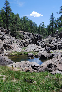
We got lost, so you don't have to. 400+ TRAILS. Search for hikes using the TRAIL INDEX on the left side of my blog roll. Happy Trails!
Tuesday, November 25, 2008
HARQUAHALA PACK TRAIL
Y-BAR
Y Bar Trail #44
Mazatzal Wilderness
Rugged, contorted escarpments of shimmering metamorphic rocks studded with high chapparal woodlands are the hallmark attractions of the Mazatzal Wilderness. The Mazatzal (which is pronounced “mah-zaht-zahl” and means land of the deer) mountains tower to nearly 8,000 feet for spectacular vista views. The Y Bar trail is a continual uphill climb along the base of Suicide Ridge through dense stands of juniper and agave. Near the 2-mile-point, the trail transitions into a heart-pumping crawl on the cliffs above Shake Tree Canyon. There, the path enters a burned area where charred pine trees and scorched snags make the remainder of the route tricky to follow. Watch for rock cairns to use as your guide.
At roughly the 4.2-mile point, the trail tops out at 6,400 feet on the Cactus Saddle, a large open area with views that stretch all the way to the White Mountains in the east. From there, the trail dips downhill to a seep area known as the Y Bar Tanks-- the turn around point for this hike.
LENGTH: 9.6 miles round-trip
RATING: difficult
ELEVATION GAIN: 2,400 feet
GETTING THERE:
From Phoenix, go north on Highway 87 for approximately 65 miles to Forest Road 419 and the signed turn off for the Barnhardt Trailhead, which is located a quarter-mile south of the town of Gisela. Follow FR 419 for 5 miles to the parking area.
Information: Visit fs.fed.us/r3/tonto or call (928) 474-7900
SYCAMORE RIM
SYCAMORE RIM
Kaibab National Forest, Sycamore Canyon Wilderness
A meager crack in a wind-swept prairie marks the origin of Arizona’s second largest canyon. In fact, the source of Sycamore Canyon is so subdued that, without an understanding of the area’s geology, you’d probably stroll right past it without giving it second thought. From its humble birthplace on the prairie, the canyon cuts a meandering 20-mile-long gorge stretching from the Colorado Plateau to the Verde Valley. A hike along the Sycamore Rim trail samples the canyon’s diversity by tracing slumping earthen edges as they fall away into gaping crevasses, dry waterfalls, natural stone tanks brimming with water and spring-fed meadows drenched in wildflower color. Although it is first runner up in size when compared to the Grand Canyon, this many-fingered precipice is second to none in geological complexity and visual interest. Landscapes--both harsh and soft--serve up a delicious dichotomy of wonders. Moving seamlessly between lifeless, stone-cold canyons and sun-washed fields of lusty, waist-high grasses, this trail is saturated with ever-changing eye candy. Interpretive signs at key points along the route explain the significance of logging ruins, water sources, geology, old roads and the delicate eco-system of a bucolic spring area where water lilies bob in shallow pine-rimmed pools.
HIGHLIGHTS: Magnificent views, deep canyon, historic ruins, spring-fed meadows.
LENGTH: 11-mile loop
RATING: moderate
ELEVATION: 3,600’ – 6,500’
Driving Distance from Phoenix: 185 miles one-way
GETTING THERE: From Flagstaff, travel west on I-40 to the Garland Prairie (exit #167). Go south on Forest Road 141 for roughly 9 miles to the turnoff on the right for Forest Road 56. Follow FR-56 for 1.5 miles to the signed trailhead. NOTE: there are five major trailheads for this hike. This one is the easiest to find. See the Kaibab National Forest website for maps.
Information: (928) 635-8200 or fs.fed.us/r3/kai
Wednesday, November 12, 2008
INNER BASIN
UPDATE: as of April 2011, this trail is OPEN. Details: http://www.redrockcountry.org/about-us/orders/04-11-01-f.pdf
The robust conifer forests that thrive in the inhospitable volcanic bowl of San Francisco Mountain can be partly attributed to an industrious and vocal bird called Clark’s Nutcracker. Easy to identify by their black-and-white feathers and sharp khaaa-khaaa-khaaa cry, the birds are consummate seed collectors. It’s common for them to store up to 100,000 pine seeds per season (many times more than they could possibly eat) in shallow underground caches. Uneaten seeds sprout and grow into trees--replenishing the birds’ food supply. The pine canopy above the Inner Basin trail is a favorite hang-out for the birds as they go about their “accidental environmentalism” by propagating the trees that slow erosion and protect an important source of water for the city of Flagstaff. Snowmelt from San Francisco mountain runs downhill and feeds springs in the Inner Basin (the collapsed crater of the 1.5 million-year-old volcano) below the peaks. As the pleasant mountain trail glides uphill, it passes several pump stations. You’ll want to tote an empty water bottle on this hike because at about the 9,400-foot point, there’s a pump house with a spigot that dispenses fresh, ice-cold spring water. Farther up the trail, another pump station has a covered viewing bench overlooking an aspen-framed alpine meadow which makes a good place to catch your breath along this high-altitude path. From there, the combination of a steep grade and thin air taxes the lungs as the path heads up to the 10,200-foot-point and the intersection with the Weatherford trail--the turnaround point for this hike. At the junction, you’ll want to linger a few moments to take in views of the surrounding Colorado Plateau where patches of trees damaged by wildfires and bark beetles are dwarfed by verdant old-growth conifers and spindly saplings—courtesy of Clark’s Nutcracker. LENGTH: 8 miles round-trip RATING: moderate ELEVATION: 8,800 – 10,220 feet GETTING THERE: From the junction of Interstates 17 and 40 just south of Flagstaff, go east on I-40 to the turnoff for Highway 89 north. Follow Highway 89 to just past milepost 431 (across from the entrance to Sunset Crater). Turn left onto Forest Road 552 and follow the signs to Lockett Meadow. Turn right at the Lockett Meadow sign and continue on FR-522 to the signed trailhead. The road is a winding dirt mountain road passable by sedan.
INFO: Flagstaff Ranger Distict, Coconino National Forest
http://www.fs.fed.us/r3/coconino/recreation/peaks/inner-basin-tr.shtml
October 13, 2011, Lockett Meadow Road is now open. ONLY HIGH-CLEARANCE vehicles are recommended; it's a really rough road. At some point in the next several months, there's a chance the road could close again for reconstruction work. And obviously it'll close for excessive rain/mud as well as the winter snow season.
As for Fall Colors in Lockett Meadow, so far there's not too much change up there. Mostly green with a few yellow bits mixed in. Hart Prairie area (FR's 151, 794, and 418) are looking nice.
WILLOW SPRINGS LAKE
WILLOW SPRINGS LAKE TRAIL
Apache-Sitgreaves National Forest
Although it’s best known as one of the best mountain bike trails on the Mogollon Rim, the Willow Springs trail also provides an invigorating trek for those who prefer to hoof-it. The route is a closed double-track dirt road that rambles through ponderosa pine forests and boggy backwaters above Willow Springs Lake. From the trailhead, the path crosses an open meadow beneath humming power lines. At about the half-mile point, the trail comes to a fork in the road. From here, it’s best to go right because the trail signage is easier to follow when the loop is hiked counterclockwise. Because the trail is surrounded by prime wildlife habitat, there’s always a good chance of spotting deer, elk and waterfowl during the hike. Near the half-way mark, the route passes several shallow ponds and marsh areas before meeting the shores of the lake. The trail parallels the water for about a quarter-mile before it turns uphill and heads back into the forest. Finding your way along this short segment is a bit tricky--look for generic trail signs tacked to trees to use as your guide. The return leg of the loop climbs up along a shaded ridge where bright blue daylilies and brilliant red paintbrush flowers blossom in the cool sheets of spring water that cascade over the trail and into the lake below.
LENGTH: 8.1-mile loop
RATING: easy
ELEVATION GAIN: 100 feet
GETTING THERE:
From the junction of Highways 87 and 260 in Payson, go right (east) on Highway 260 and continue to Larson Ridge Road (Forest Road 237). Turn left on FR-237 and continue a short distance to the parking area with restroom on the left just south of Forest Road 237A. The trail starts a few yards up the road from the parking area at an unmarked gate on the left. From there, follow the generic blue trail blazes and “bike” signs.
This description turns right at the first major junction.
SEE CANYON
SEE CANYON
Nothing says “autumn in the high country” quite like a willowy stand of golden-crowned aspens. Transient and opportunistic, aspen trees rely on forest fires for their survival. In their natural cycle of life and death, aspens can only sprout and regenerate when bathed in sunlight. Young aspens literally rise from the ashes of sun bathed burned areas and thrive for years until encroaching pine trees catch up and choke out sunlight and nutrients. Eventually, the aspens dwindle, and their subterranean root systems go dormant until fire clears the canopy again. A hike on the See Canyon trail is like getting a field lesson in the lifecycle of this tenacious, showy species. From the ancient knarly-trunked hangers on that refuse to succumb to the clutch of predatory pines to spindly, soot-covered sprouts on barren charred slopes, the aspens chronicle how fire has transformed the landscape over time.
To find the route, descend down through a wooden fence that’s located to the right of the parking lot trailhead sign. Bear left and head down toward the creek. Cross the creek, head up the bank and then veer right along a faint path to the signed intersection for the Highline and See Canyon Trails. Turn left at the junction where the See Canyon trail sign is sometimes covered by tall vegetation. The first portion of the trail is usually overgrown with soft grasses and washouts may camouflage the trail in places, but by paying attention to the metal trail markers that are nailed to trees, it’s not too difficult to stay on track. The trail crosses Christopher Creek several times before it leaves the green streamside environment behind and begins an arduous 1,700-foot climb up to the rim. For an easier option, turn right at the junction for See Spring Trail #185 that branches off the main path before the going gets rough. The See Spring Trail is a half-mile in length and dead ends at the spring. Intrepid hikers can opt to stay on the main trail and complete the uphill grind to experience exquisite vistas and plenty of fresh mountain air on the 7,860-foot-high crest of the Mogollon Rim.
LENGTH: 4.8 miles one-way
RATING: difficult
ELEVATION: 6,100 – 7,860 feet
PEAK COLOR: mid October
GETTING THERE:
Lower trailhead: From Payson, go right (east) onto Highway 260 and continue for 20 miles to the Christopher Creek Loop exit. Continue on Christopher Creek Loop to Forest Road 284, which is located directly across the road from the Tall Pines Market. Follow FR 284 for 1.6 miles (ignore the many dirt spur roads; stay on the gravel) to the signed circular parking area where there’s a restroom and a corral.
Rim Road trailhead: From Highway 87, go east on FR 300 for roughly 30 miles to the signed trailhead on the right.
DREW TRAIL
DREW TRAIL
While the downside of wildfires is the destruction of our beloved woodlands, the upside is improved forest health and the opening up of previously obscured views. Although recent wildfires have denuded sections of the Drew Trail, the result has been mostly positive. Before the fires, dense stands of trees (some unhealthy due to bark beetle infestation) had blocked views that now showcase the stunning geology and beauty of the area. The hike starts out at the See Canyon trailhead below the Rim Road and then heads east on the Highline trail through a 2.25-mile-long checkerboard of creek side ferns, manzanita scrub and soaring pines before it encounters the Drew Trail junction. From here, the hiking becomes more difficult as the final stretch of the steep path climbs 820 feet in just over a mile. As the route gains elevation, the fire damage wanes and the forest grows thicker. Finally, at trail’s end on top of the 7,600-foot escarpment, shimmering aspens, billowing oaks and a healthy crowd of unscathed pines shade the path.
LENGTH: 7 miles roundtrip
RATING: moderate
ELEVATION: 6,780 – 7,600 feet
PEAK COLOR: mid October
GETTING THERE:
Lower trailhead: From Payson, go east (right) on Highway 260 for 21 miles to the Christopher Creek Loop exit. Continue on Christopher Creek Loop to Forest Road 284, which is located directly across the road from the Tall Pines Market. Follow FR 284 for 1.6 miles (stay on the main gravel road ignoring the many spur roads) to the signed See Canyon trailhead where there’s a restroom and corral.
Rim Road trailhead: located roughly 6 miles from the Highway 260/300 turn off near FR 9350, marked only by a generic trail post. Consult a good forest service map to make sure you’ve found the right path.
BARBERSHOP TRAIL
BARBERSHOP TRAIL
This undulating route penetrates the thick forests of Barbershop and Dane Canyons where, in autumn, a wide variety of trees and plants paint the landscape in a riot of warm color. Along this trail, a multi-level canopy of foliage begins on the forest floor where oaks with spiced mustard tinged leaves compete for space among compact blue spruce trees. Above the oaks, Bigtooth maples blush crimson against cool, blue green firs. Towering high above the confetti-like layers of airborne leaf litter, graceful white-barked aspens and Ponderosa pines seem to brush the clouds in a wind-fueled arboreal ballet. The trail, which is named in honor of a long-gone sheepherder who used his sheering blades to give haircuts to cowboys, ducks in-and-out of the forest, and passes through sunny meadows of spent ferns and golden-brown grasses. Adding visual interest to the trail, are two lush, soggy spring sites which feed hardy daisies and yarrow flowers that bloom stubbornly until the first frosts of late autumn send them down for the winter.
LENGTH: 4.5 miles one way
RATING: moderate
ELEVATION: 7,200 – 7,600 feet
PEAK COLOR: early October
GETTING THERE:
From Payson, go east (right) on Highway 260 for 30 miles to Rim Road (Forest Road 300, which is located across from the Rim Visitor Center). Follow FR 300 for 23 miles to Forest Road 137. Turn right on FR 137 and drive 4 miles to the trailhead, which is located across the road from Buck Springs Cabin.
Information: Coconino National Forest, Mogollon Rim Ranger District, (928) 477-2255, fs.fed.us/r3/Coconino/recreation/mog_rim/barbershop-tr.shtml