Monday, October 27, 2008

TAVASCI MARSH


TAVASCI MARSH
Dead Horse Ranch State Park

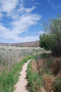
Situated in the backwaters of the upper Verde River, Tavasci Marsh is a bird watcher’s paradise. Herons, egrets, finches, wrens and flycatchers flourish in the profuse vegetation and aren’t shy about spreading their wings. The hike passes through a healthy mesquite bosque—one of the most rare ecosystems in the world—ending at a wooden observation deck with a viewing bench at the edge of the wetlands. Here, river otters cut through pond water like oiled torpedoes accompanied by a boisterous avian soundtrack.

LENGTH: 3 miles round-trip
RATING: easy elevation gain: 50 feet
ELEVATION GAIN: 3,350’ – 3,300’

GETTING THERE:
From Phoenix, go north on Interstate 17 to Camp Verde (exit 287) and take Highway 260 west to Cottonwood. Turn left on Main Street (89A toward Clarksdale) and continue to 10th Street. Turn right on 10th St. and proceed over the Verde River Bridge to the park entrance. From the park entrance, follow the main road to Flycatcher Road (2nd road on the left) where there’s a “Tavasci Marsh” sign. Follow this road less than a mile to the signed parking area.

RIO SALADO


RIO SALADO HABITAT RESTORATION PROJECT

Just two miles south of downtown Phoenix, where the Salt River once flowed, a former dumping ground has been transformed into a thriving 595-acre oasis in the desert. With the cooperation of the Army Corps of Engineers, the Flood Control District of Maricopa County and droves of volunteers, tons of waste were cleared out of the Salt River channel and replaced with ponds, waterfalls and tens of thousands of indigenous plant species. Although the 5-mile-long strip of riparian habitat looks as if it occurred naturally, it’s actually a “demonstration wetland” that was created by tapping into the groundwater beneath the river channel and pumping more than 2.65 million gallons of water per day to sustain the habitat. Stretching from 19th Avenue to 16th Street, the project is a work in progress. The Central Avenue gateway is currently the most complete segment and there’s parking, interpretive signage, restrooms and drinking water. Trail segments are organized to feature specific desert habitats such as Cottonwood-Willow, Lower Sonoran, Mesquite Bosque and Palo Verde. Although just a few years old, the plants—which were harvested from seeds or cuttings within a half-mile of the Salt River—are already flourishing and attracting wildlife. Snowy Egrets, raptors, toads and dozens of other species have settled in. Future plans for the project include adding more gateways to access the more than 10 miles of paved and dirt trails and an Audubon Nature Center.

LENGTH: about 10 miles of paved and dirt trails are planned. As of 0506, about 3 miles of established trails are open.
RATING: easy and informative
ELEVATION GAIN: 50 feet

GETTING THERE:
From Phoenix. Drive south on Central Avenue through downtown. Just past the I-17 underpass, look for the obvious parking area on the leftAlternate routes:
From the east Valley, take Highway 60 west and connect to I-17. Exit I-17 at 7th Street. Go south on 7th Street to Broadway Road. Turn right (west) on Broadway Road and continue to Central Avenue. Turn right onto Central Avenue and head north for about 1 mile to the gateway.
From the west Valley, take I-10 to I-17 and exit at 7th Avenue. Go south on 7th Avenue to Broadway Road. Turn left (east) onto Broadway Road and go to Central Avenue. Turn left (north) onto Central Avenue and continue for about a mile to the gateway on the right.
COON BLUFF

COON BLUFF Tonto National Forest Sunrise over Coon Bluff is sometimes greeted by a herd of wild mustangs wandering on the shores of the Lower Salt River. Early morning is the best time to sight the horses and a seat on top of Coon Bluff offers the best vantage point for viewing the elusive beasts. Coon Bluff’s rugged escarpment flanks the river and is one of several scenic high points along a maze of unofficial trails that meander through the desert terrain above the confluence of the Verde and Salt Rivers. To reach the bluff, just follow the wide paths uphill and take your pick of the many options along the ridges. There are several spur trails that lead down to the water. There, water birds and raptors chatter in the mesquite trees that thrive along the sandy shore. Although sighting a bald eagle or a turkey vulture is pretty common, catching a glimpse of the mustangs requires more patience. On days when they show up, they appear like ghosts and then disappear back into the desert in a flash of commotion that leaves behind hoof prints and a cloud of dust. LENGTH: 3 miles round trip RATING: moderate ELEVATION : 1,486' - 1,593' GETTING THERE: From Phoenix, go east on US 60 to the Power Road exit. Continue north on Power Road, which will turn into the Bush Highway, and then turn left on the Phon D. Sutton Recreation Site Road. Drive about 100 feet and park in the corralled dirt lot just before the gate. The hike starts at the generic trail sign. INFO:  Mesa Ranger District, Tonto National Forest, 480-610-3300

http://www.fs.usda.gov/wps/portal/fsinternet/!ut/p/c5/04_SB8K8xLLM9MSSzPy8xBz9CP0os3gDfxMDT8MwRydLA1cj72BTSw8jAwgAykeaxcN4jhYG_h4eYX5hPgYwefy6w0H24dcPNgEHcDTQ9_PIz03VL8iNMMgycVQEAIzTHkw!/dl3/d3/L2dJQSEvUUt3QS9ZQnZ3LzZfME80MEkxVkFCOTBFMktTNUJIMjAwMDAwMDA!/?ss=110312&ttype=recarea&recid=35399&actid=43&navtype=BROWSEBYSUBJECT&position=BROWSEBYSUBJECT&navid=110190000000000&pnavid=110000000000000&cid=FSE_003723&pname=Tonto+National+Forest+-+Coon+Bluff

O'LEARY PEAK


O’LEARY LOOKOUT TRAIL
Coconino National Forest

A “middle child”, O’Leary Peak often plays second fiddle to its more famous siblings—the San Francisco Peaks and Sunset Crater. In comparison to the rival peaks, O’Leary is truly middling in height, age and relative location. The 250,000-year-old lava dome volcano rises to an impressive 8,916 feet and although it lacks the star quality that draws hordes of tourists and hikers to the other two peaks, O’Leary is anything but the ugly step sister.
The trail up O’Leary Peak is just a 4x4 road that’s still used by forest service workers to get to the fire lookout on the summit. The hike begins by flanking a thick, inky-black lava flow with views of the distinctive rust-colored slopes of Sunset Crater in the distance.
The lower path is mostly made of black and red cinders that crunch under foot. The first 3 miles are easy going, gaining elevation gradually, but the grunt work begins where the road meets the mountain and becomes much steeper. Crystalline cliffs of dacite, the volcanic rock that pushed up from the earth’s core to build O’Leary Peak, line the trail that’s little more than a narrow cut in the mountainside. On the top, there are amazing aerial views of Sunset Crater and the Bonito Lava Flow. To the north, the Painted Desert shimmers in the haze and to the west; Arizona’s grandest peaks get up close and personal. While taking in the 360-degree smorgasbord of sights, you’ll wonder why all the little cars on the roads below are zooming right past O’Leary Peak.

LENGTH: 10 miles round trip
RATING: Moderate
ELEVATION: 6,930 – 8,916 feet

GETTING THERE:
From Phoenix, take I-17 North to Flagstaff. In Flagstaff, take I-40 east and then connect to Highway 89 north. Continue north on Highway 89 to the signed exit for Sunset Crater National Monument (FR 545) and turn right. Continue for less than a mile and then turn left at the “O’Leary Group Campground” sign onto FR 545A. Drive a short distance past the fee area campground to the gate and signed trailhead for “O’Leary Lookout”. There are restrooms and running water at the campground. The dirt roads are accessible by sedan.

Wednesday, October 8, 2008

APACHE VISTA


APACHE VISTA
Apache-Sitgreaves National Forest

UPDATE:
This trail has been impacted by the WALLOW FIRE, June 2011.


Hovering over the town of Springerville in Arizona’s White Mountains, the Apache Vista Trail #617 showcases outstanding high-country scenery. Situated at 9,000 feet in elevation, the gentle path traipses through wide-open alpine meadows along the edge of a deep, forested canyon. Cool summer temperatures and ample rain foster profuse growths of multi-colored wildflowers and towering old-growth conifers. It’s no accident that the trail has the word “vista” in its name. Expansive views of volcanic fields and river gorges that stretch all the way into New Mexico are this trail’s signature attraction.


Length: 5.2 miles round-trip
Rating: easy
Elevation gain: 50 feet

Getting there: From downtown Eagar, go west on Highway 260 for roughly 3 miles to the Highway 261 junction. From there, turn left (south) on Highway 261 and continue for 7.2 miles to the trailhead on the left.

FAY CANYON


The "shark fin" at trail's end


The ruins beneath the arch are likely reconstructed


Fay Arch


inside Fay Arch


Typical scene along the trail
FAY CANYON TRAIL Red Rock Secret Mountain Wilderness, Sedona Hiding in plain site in the cliffs above Fay Canyon Trail, are historic and geological wonders you won’t want to miss. However, you’ll need a keen eye to locate them. About a mile into the shaded high-desert canyon, look for an artful cairn and a faint spur trail on the right. From there, Fay Arch and remnants of an ancient stone structure are visible in the cliffs high above the trail. A short but steep hike up to the arch is worth the effort because the enormity of the Supai sandstone bridge and the adjacent slot canyon is best experienced up-close. The exploratory adventure doesn’t end at the ruins, though. The trail terminates at a prominent “shark fin” formation surrounded by cliffs that offer easy climbing and impressive views of Sedona. LENGTH: 2.4 miles round-trip RATING: easy (with a tricky optional side trip) ELEVATION: 4,500'-4,800' Fees: A Red Rock Pass ($5 daily fee per vehicle) is required. GETTING THERE: From the junction of Highways 179 and 89A (the “Y” traffic circle intersection) in Sedona, turn left onto Highway 89A and continue for 3.2 miles to Dry Creek Road. Turn right on Dry Creek Road (Forest Road 152C) and continue 2.9 miles  to the  Long Canyon/Boynton Canyon Road intersection. From here, turn left to stay on FR-152C and continue to Boynton Canyon Road. At the intersection, turn left onto Boynton Pass Road and drive for about a half-mile to the trailhead on the right.

INFO: Red Rock Ranger District, Coconino National Forest

http://www.fs.fed.us/r3/coconino/recreation/red_rock/fay-canyon-tr.shtml

WINDMILL HIKE


WINDMILL HIKE
Superstition Wilderness

Free-form in nature and easy to access, this hike follows a casual maze of trails that meander among dilapidated, tin-roofed corrals, wooden fences and a windmill that lost its blades years ago. The ruins are surrounded by twisted barbed wire and stand as decadent sentries in an expansive desert canyon where herds of cattle once enjoyed the shade and fresh spring water that still feeds water holes scoured out of the area’s volcanic crags. The trail begins on an old dirt road that leads to the ruins. From there, narrow footpaths lead to many points of interest including a spectacular slot canyon where the songs of vociferous cardinals and canyon sparrows bounce off the cliffs and harmonize with the sound of rusty metal swaying in the breeze.

Length: 2 miles round-trip
Elevation gain: 180 feet
Rating: easy

Getting there:
From Phoenix, take Highway 60 east to the Highway 88 (Idaho Road) exit. From there, go left at the intersection and continue on Highway 88 to the turn off for First Water Road (Forest Road 78). Follow FR-78 to the horse staging area and park in the adjacent lot. Hike back out onto FR-78 and continue for a short distance to an unmarked dirt road on the left. There’s a gate a few yard in from the road, which marks the beginning of the trail.

TABLE TOP MESA


TABLE TOP MESA
Table Top Wilderness Area

WARNING JULY 2010: THE BUREAU OF LAND MANAGEMENT HAS POSTED A WARNING SIGN ALONG THE ACCESS ROAD TO THIS TRAIL ADVISING OF DANGERS ASSOCIATED WITH ILLEGAL DRUG SMUGGLING ACTIVITIES. PROCEED AT YOUR OWN RISK!
Near the 4,356-foot summit of Table Top Mountain, a series of low walls stand in stony silence over the sprawling desert lowlands of the Vekol Valley. Blurring the border between truth and legend, the origin and purpose of the walls is shrouded in mystery, baffling archeologists and geologist alike. Easy-to-spot from the freeways near Casa Grande, the distinct, solitary flat-topped mesa is a familiar landmark rising 2,000 feet above hazy cotton fields and desert plains. Getting to the top is easier than it appears, though. An obvious, gradual trail crawls up the mountain through bajadas, ancient basalt lava flows and pristine communities of ironwood and mesquite to the crest of the mesa. There, a breezy, 40-acre yucca-dotted grassland rolls out like an overgrown shag carpet stitched together in loose clumps of sun-bleached, earth-tone fodder.

LENGTH: 7 miles round-trip
RATING: moderate
ELEVATION: 2,300 – 4,356 feet

Getting there:
From Phoenix, travel south on Interstate 10 to Interstate 8. Go west on I-8 to the Vekol Valley Interchange (exit 144). From there, go south on Vekol Road for 2.1 miles to the Vekol Ranch turnoff, veer right, and follow the “trail” posts for 15.2 miles to the signed campsite with vault toilets. The dirt access road is well maintained and marginally passable by sedan. However, a high-clearance vehicle is recommended due to some sandy portions and deep ruts. A 4-wheel drive vehicle is required if the roads are wet.
Information:
Visit: azwww.az.blm.gov/pfo/ttm.htm or call (623) 580-5500

Thursday, October 2, 2008

ELEPHANT MOUNTAIN

Elephant Mountain Spur Cross Conservation Area Located just a few minutes north of Scottsdale, the rugged beauty of Spur Cross Ranch Conservation Area is an island of pristine Sonoran desert surrounded by a sea of golf greens and adobe rooftops. The Elephant Mountain trail uses a maze of old Jeep tracks and primitive paths that cut through stream washes, grasslands and boulder fields to explore a remote section of this area. The commotion of the busy trailhead is soon left behind as the trail descends along a volcanic ravine where ancient ruins pepper the landscape. The ruins themselves are difficult to locate—and that’s the way park rangers would like to keep it—to help preserve the fragile artifacts. However, it’s still possible to learn more about the ruins by participating in ranger-led interpretive hikes. About a mile into the hike, at the Tortuga-Elephant Mountain trail junction, the distinct pachyderm profile of Elephant Mountain takes center stage. From here, the destination is clearly visible. The trail heads up hill to a saddle below the “tusks”. The saddle, located at the 3.5-mile point, offers panoramic views of Sugarloaf Mountain, Skull Mesa and the McDowell Mountains. But that’s not the best part—teetering atop the “tusks” are a series of ancient stonewalls. However, don’t even think about scrambling up to explore them because the area is off limits, except, of course, to ranger-led hikes. LENGTH: 9.2 miles out-and-back RATING: moderate (route-finding skills are required) ELEVATION: 2,400' - 3,200'  FEE  $3 daily fee per person. The self-pay station requires exact change. GETTING THERE:  From Loop 101IN north Phoenix, exit at Cave Creek Road and drive north for approximately 15 miles to Spur Cross Ranch Road. This is an easy-to-miss junction located just before entering the busy main drag of Cave Creek.  It is signed and the turn off is on the left. From here, the road jogs north and then makes  a tight turn to the right to another funny junction.  There's a BIG sign here pointing north (go left) to Spur Cross Ranch. Continue north for 4.2 miles to the parking lot on the left. The last mile of the road is good dirt and passable by sedan. HIKE DIRECTIONS: Follow the Tortuga trail for 1.2 miles to the Elephant Mountain trail junction. From there, the trail becomes primitive, marked only by rock cairns and faint footpaths.

INFO  & MAPS : Spur Cross Ranch Conservation Area: http://www.maricopa.gov/parks/spur_cross/

A.B. YOUNG TRAIL


Oak Creek flows at the base of the rim


East Pocket Fire Tower


Limestone formations along the trail


Oak Creek cascade


East Pocket Fire Tower


YOUNG TRAIL #100
Sedona
This hike has everything --water, high-desert ridges, a grueling climb and a pleasant traipse through a pine and oak forest to the historic East Pocket fire lookout.
The trail begins in the Bootlegger Day Use Area near site number two.  From there, descend the flagstone stairs to Oak Creek and follow the generic trail markers to the creek. Boulder-hop the water and head toward the stone retaining wall where there’s a metal “A.B. Young #100” sign.  The ascent begins immediately through a cool, creek-side environment that quickly transcends into a pine forest. After about the half-mile point, the trail leaves the shade and begins switch backing up steep sun-drenched cliffs on its way to the 7,196-foot West Rim of Oak Creek Canyon.  Many spectacular rock formations and great views of the narrow canyon open up as the trail gains elevation.  Once on the rim, follow the carins into the forest to the wooden “A.B. Young/Oak Creek” sign that marks the official end of the trail. To reach the East Pocket fire lookout, continue for just under a mile following a series of huge rock cairns. Staffed by a USFS worker during the fire season, visitors are welcome in the funky old 1930s-style wooden tower.


LENGTH:  6 miles round trip
RATING:  difficult
ELEVATION: 5,100’ – 7,196”
FACILITIES: restroom
FEE: a Red Rock Pass is required: there’s a permit kiosk at the trailhead that takes paper, plastic and coins. http://www.redrockcountry.org/passes-and-permits/index.shtml
GETTING THERE:
From Phoenix, take I-17 north to the Sedona-Oak Creek exit 298 for SR179.  Head left (west) on SR179 and continue to the Sedona “Y” intersection of SR 179 and US89A. Veer right (north) through the traffic circle and continue 8.8 miles to the Bootlegger Day Use Area near milepost 383. Roads are 100% paved.
INFO:  Red Rock Ranger District, Coconino National Forest, 928-282-4119